Port Vincent, Southern Yorke Peninsula, South Australia
From coastal grain port to holiday resort.
To purchase a Carto Graphics map of the Yorke Peninsula, click here
Port Vincent is located approximately half way down the east coast of the Yorke Peninsula, and is about a two hour drive from Adelaide via the national highway 1, then turning off just north of Port Wakefield onto the Copper Coast Highway, then several kilometers along, southwards onto the St Vincent Highway (formerly known as the ‘Coast Road’).
Port Vincent can also be easily reached by sailing across the Gulf of St. Vincent from the Adelaide foreshore, a distance of approximately 60 km.
Back in the early days of South Australia, people from the developing city of Adelaide would quite often sail over for a day’s fishing, or general coastal exploration of the Yorke Peninsula. Especially land-holders seeking new pastures for their livestock.
Various South Australian government ventures for the residential sale of town allotments were promoted from about 1852, with three large allotments totaling some 500 acres being taken up for cropping, the majority being on high ground to the west of the town. The first really successful residential land sales occurred in September of 1877, when the fledgling Advertiser newspaper advertised residential allotments for sale in the ‘Beautiful Township of Port Vincent’.

During the years from 1852 up to 1877 the only access to the town area, then called ‘Surveyor’s Point’, was by coastal sailing ketches. Coming close in shore on high tide they sat on the sandy bottom during low tide and farmers with horse and cart went out to each ketch and unloaded the in-coming cargo by hand onto the beach. Sometimes when the ketches could not get in close enough to the beach, small boats were used to unload the cargo. Any out-going cargo to Adelaide was handled in the same manner.
Early in 1877 private enterprise stepped in and decided to construct a jetty and cargo shed at almost the center of the horseshoe-shaped long sweeping bay. The jetty commenced at the high tide mark, almost where the current Deli now is, and running out into the bay for a distance of 120 feet, x 16 feet wide. The cargo shed was constructed at the shore end of the jetty. A tram track was added to the jetty enabling horse-drawn jetty trolleys to be used to collect cargo from incoming ketches and deliver it to the cargo shed where it was stored until collection by various owners. Outgoing cargo was also loaded onto the ketches the same way.
The track was a single track for the first sixty feet, then double-track out to the sea-end of the jetty. Upon completion of the jetty and cargo shed, the Government of the day then decided spend about one thousand pounds on levelling the inland sandhills, and metalling the access track for a distance of 28 chains, (1,848 feet), which greatly increased accessibility to the jetty and general beach area. In doing so they encouraged Adelaide people to gradually move to and construct homes in Port Vincent.
As the surrounding land was all privately owned, the Government could not do any official town surveying. Therefore all the town’s allotments are privately surveyed with varying degrees of accuracy. Allotments vary from quarter acre up to nearly three-quarter acre, with very few being 100% square, which over the ensuing years has led to some very interesting boundary fence lines!
By 1899 the jetty and tram track were showing years of heavy use so it was decided to construct a wharf. This was duly commenced in early 1901 with the low-lying land to the north of the old jetty filled in and the first hundred feet of the new wharf constructed, followed in two more stages until the wharf stretched some 450 feet.
A Government contracted dredge deepened the shipping channel and swinging basin to 1400 feet out to sea. Two pile-mounted channel markers were also erected at the same time. During 1905 the shipping channel was extended to 2000 feet, and another pile-mounted channel marker erected at the beginning of the now-extended channel.
About 1918 the old jetty was removed with all ships using the wharf, which was safer, and much faster too, especially as the grain handling area was directly behind the wharf and easily accessible from the metalled beach road.
Besides the coastal ketches, small Steam Ships such as the SS Ceres and the SS Star of Hope, and later the SS Juno, carried passengers and general cargo on a regular twice-weekly run from Port Adelaide across the Gulf to Port Vincent from the 1880s up to the late 1920s when larger and more modern steamers took over. They supplied the town up to about 1949 when the motor vehicle transport began taking over with the construction of good roads leading up the peninsula and connecting to the National Highway at Port Wakefield. Local roads were all constructed before 1949, but most were not much more than bush tracks designed for horse and cart or horse and wagon use.
It was only after the construction of the wharf and the surrounding grain storage section that Port Vincent finally started to go ahead and become a small town servicing the surrounding farms. The town gained a flour mill, the Hotel, the General store, tearooms, blacksmith, school, church and in 1907 a Bank Agency. In 1910 the Town’s Institute building was commenced on land to the south of the hotel fronting the Beach Road (now called ‘Marine Parade’) on the corner of Curramulka Street.
To purchase a Carto Graphics map of the Yorke Peninsula, click here
During the 1920s three major oil companies opened storage and distribution depots in Port Vincent. From these depots fuels and lubricating oils were distributed throughout the Peninsula from about Arthurton in the north and southwards to the ‘Bottom End’ of the peninsula. Port Vincent’s wharf, and its closeness to Port Adelaide led the companies to prefer this location over the other peninsula ports. Vacuum Oil Company (Mobil) was the first on the scene, to be followed by British Imperial Oil Company Limited (Shell), then Commonwealth Oil Refinery, (COR.- now called ‘BP’).
Although Vacuum had the largest depot area and storage section with holding tanks totaling 14,000 gallons, all their products arrived in 44 gallon drums or in four gallon cans. Shell constructed a fuel pipeline from the town wharf, running along under one side of the main street, to the Shell Depot, where the holding tanks were of much larger capacity. There were two 200 000 gallon tanks and two 100 000 gallon tanks and a 30 000 gallon settling tank, plus other smaller 1 000 gallon tanks as well.
Shell initially used a small oil tanker to supply the town from Port Adelaide, but a fuel barge towed by a tugboat was proved to be cheaper and more efficient to operate, and this method was used up to about the mid 1950s. When improvements to the roads and the more practical use of road cartage fuel tankers came to the fore, the Port Vincent Bulk Storage depots were wound down and bulk storage depots were then set up in all of the main Peninsula towns, with fuel then being delivered by a local agent in each locality. All three bulk fuel depots in Port Vincent were closed by 1960.
In the mid 1960s bagged grain handling was also decreasing with bulk handling becoming more prevalent with the opening of the Wallaroo Silos, followed by the Ardrossan Silos, then in 1969 the opening of the first set of concrete silos at Port Giles. This was soon followed by the opening of the Port Giles Bulk-loading Jetty.
All these changes impacted all the smaller coastal ports. Some survived to become popular tourism or retirement towns, keeping all their local businesses. Others simply became a row or two of holiday homes and not much else.
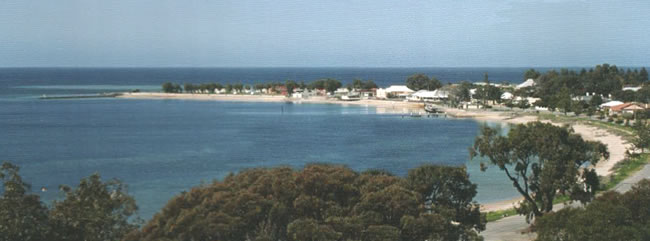
Port Vincent being already relatively well-known for its safe beach and shallow sweeping bay, which is protected by the south-east sand-spit from southerly gales, was one of the lucky coastal towns. Tourism was already developed thanks to the weekly steam ships that plied the Gulf bringing over holiday-makers from Adelaide on a regular basis.
With the sealing of the Coast Road, now named the St Vincent Highway, in the mid-1960s, access to Adelaide and other regions greatly improved as the average drive by car to the city became about two hours, instead of about four hours on the old gravel road. This attracted many more people to drive over, either for a weekend or quite often several weeks. Some stayed at one of the town’s caravan parks, some at various holiday units, and some hiring a rental cottage. Most kept on coming back bringing family and friends along too. Some bought houses, some bought allotments & built their own homes. Others built investment houses and rented them out for permanent rentals or for short-term holiday rentals.
Some came to retire and enjoy the relaxed lifestyle – fishing, boating, swimming, playing golf, bowls, tennis, or simply taking a quiet walk along the beach almost every day.
To purchase a Carto Graphics map of the Yorke Peninsula, click here
IF anyone from a 100 years ago could visit Port Vincent today, they would find quite a different town. It has grown over the years, from a small township of about 100 permanent residents, to a fixed population of nearly 500 residents, which swells in the summer months to about 2,000 people, especially during the annual Christmas and January school holidays.
There’s a new sub-division at the back of the main town area with approximately 80 new homes, while along the northern foreshore there is now a new marina with allotments for another 60 homes. Many of these have water frontage and their own mooring pontoons. Near the town centre where the old grain stacks used to be is all grassed picnic areas, and two car-parks plus public conveniences. The wharf has been reduced from some 450 feet down to about 100 feet in length with a short fishing jetty added to the northern end. Almost every day in hot or cold weather one can find a local or two fishing off either the wharf or the jetty. During holidays the wharf and jetty are packed with people of all ages having a go at attempting to catch a fish or two,- and sometimes they even catch a blue crab or two as well, without even trying.
In 2003 the Port Vincent Community was awarded the ‘Best South Australian Rural Community’. In 2004 Port Vincent was pronounced ‘The Tidiest Town in South Australia’ and went on to win the Australian Tidiest Town Award for 2004. This was a fitting reward for the many hours the local Tidy Towns group of volunteers spend every year recycling bottles and cans and keeping the town’s beach front and park land neat and tidy. Local primary school children who are taught to take pride in their town also help, and contribute through the School’s Marine Studies Centre and various other local community activities.
During the year groups of students from other schools come to stay at Port Vincent for a week at a time to learn or improve their swimming, sailing and various other aquatic activities organised through the Port Vincent Aquatics Centre.
Today Port Vincent has a modern 7 day IGA supermarket, hardware store, two service stations, a butcher, deli, beach-side kiosk, hotel, coffee shop, hairdresser, chemist, news-agency, real estate office, two churches, primary school, Post Office, various Community clubs and groups including Senior Citizens, sports store with kayaks, bicycles, etc for hire, plumber, several builders, electricians, gardening services and a landscape designer, a wooden toy maker / designer.
For the tourist, there’s two caravan parks both with modern self-contained cabins, plus a selection of independently-owned holiday cabins, flats, units and homes for holiday rental, which are crammed to capacity during the peak holiday season over the Christmas New Year period. The Port Vincent annual New Year’s Day Gala happens at this time. The main foreshore section is closed off and becomes a fairground for the day. Craft items are for sale in the institute hall and numerous stalls with items for sale/ display along the street, with music entertainment supplied by a live band. At the completion of the Gala Day there is a fireworks display on the stone breakwater adjacent the foreshore caravan park. The spectacular display lights up the bay and the foreshore area.
Researched by Roger Jenkins, Port Vincent, Southern Yorke Peninsula, South Australia.
Historic information sourced from the Port Vincent History Book, and various local tourism information sources.
Copyright © Roger Jenkins, August 2012.
To purchase a Carto Graphics map of the Yorke Peninsula, click here
This page Copyright © ThisisAustralia.au
All the labels you use every day, with excellent service! EveryLabels.com.au